")
Task 145
Model based study of DC-Baltimore Urban heat island
Principal Investigator(s):
R. Murtugudde
Collaborators:
M. Ganeshan
Sponsor(s):
M. Imhoff
Last Updated:
October 26, 2012 15:25:39
Description of Problem
This task provides additional support to look at the use of Terra and other data sets in the application of urban related impacts to the Chesapeake Bay environment within the context of the on-going CBFS. The impact of Urbanization, land use, and heat island effects on weather and climate is being studied in a dynamic downscaling framework for Regional Earth System Prediction. Urban areas are known to alter local temperature and winds due to differences in surface roughness, albedo, and surface sensible and latent heat fluxes. As the human population continues to grow we can also expect urban areas to expand and potentially affect weather and climate on a regional scale in some areas.
The Urban Heat Island (UHI) impact of DC-Baltimore on local precipitation is studied using WRF at 500m resolution. The various processes related to urban surfaces are simulated using an urban canopy model in combination with NOAH’s Land Surface Model. The heavy precipitation event that occurred on 13th-14th July 2010 in the DC-Baltimore area is analyzed.
Scientific Objectives and Approach
We plan to run high resolution WRF simulations (2-km), using NARR as forcing, over the upcoming year with the goal of determining the extent of the Baltimore-Washington urban heat islands under different synoptic weather conditions. In addition, we will run simulations with the urban areas removed and expanded by arbitrary amounts for comparison with the present day condition. We will use the NOAH land surface model urban scheme along with MODIS land cover data. We had originally hoped to compare Terra/Aqua derived profiles of temperature and water vapor to the model output, however, the data lack sufficient vertical and temporal resolution for this purpose.
Accomplishments
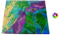
The nocturnal UHI for DC and Baltimore appears to be stronger than the diurnal one. The model captures heavy precipitation in the vicinity of both cities during the 2-day rainfall event. In particular, it simulates a nocturnal storm that passes directly over DC on 13th July 2010 at around 11p.m. LT (Fig.1(a)).
Figure 1(b) shows the urban heat island simulated by the model one hour prior to the occurrence of the storm (10p.m. LT). The 2m air temperature over the core of DC is up to 3-4°K warmer than its surroundings. The temperature gradients between the capital city and its neighboring areas are strongest in the northern and western regions. In cities with a pronounced UHI, the warmer temperatures can often lead to local convergence and hence result in higher precipitation.
As the storm moves over DC, however, the maximum rainfall does not occur over the city itself. Instead the heaviest precipitation is predicted to occur to the west and northwest of DC (Fig.1(a)). It appears that this spatial pattern of heavy precipitation is a direct result of the strong temperature advection at the surface (Fig.1(b)). It is a well-known fact that both temperature and moisture advection can lead to local instabilities that produce precipitation. The downwind impact of UHI on precipitation has been well documented in previous studies. It is possible that the temperatureor thickness advection due to strong gradients between the city and neighboring areas could play an important role in enhancing downwind precipitation.
Through our study, we seek to identify the dominant patterns of rainfall resulting from DC-Baltimore’s UHI. The role of thermal, moisture and other gradients will be investigated. The impact of replacing the urban cover with natural land cover will be studied. Also, we will examine possible plans for the future expansion of the city in order to identify land-use land-cover changes that have the least impacts on precipitation, temperature and other parameters.
A script was written to modify the extent of urban cover in the input surface files for WRF. Several sets of WRF runs have been made on a 500-m grid centered on the Washington DC–Baltimore area. The runs were done in pairs, one control run with current urban cover distribution as determined from MODIS, and one perturbation where the urban cover was replaced with deciduous forest. The urban heat island appears to be 1-4 C warmer than the surrounding area and is strongest in the night. Preliminary results suggest that the DC-Baltimore heat island may increase precipitation downwind of the cities by increasing 1000-500 mb advection.


