")
Task 202
Ground-based Supersite/Network Measurements in Support of NASA/EOS Missions
Principal Investigator(s):
Q. Ji
Sponsor(s):
S-C. Tsay
Last Updated:
October 26, 2012 15:25:42
Description of Problem
According to NASA’s Science Mission Directorate (SMD), "in order to study the Earth as a whole system and understand how it is changing, NASA develops and supports a large number of Earth observing missions. These missions provide Earth science researchers the necessary data to address key questions about global climate change." (http://science.nasa.gov/earth-science/missions). As a major component of the Earth Science Division of NASA/SMD, "the Earth Observing System (EOS) is a coordinated series of polar-orbiting and low inclination satellites for long-term global observations of the land surface, biosphere, solid Earth, atmosphere, and oceans." (http://eospso.gsfc.nasa.gov). As the EOS follow-on, "the Decadal Survey will generate consensus recommendations from the Earth and environmental science and the applications communities regarding a systems approach to space-based Earth Science observations." (http://decadal.gsfc.nasa.gov). However, satellite observations alone is not sufficient to provide a complete understanding of the complex earth-atmosphere system. Extensive ground-based measurements and comprehensive modeling analysis are also indispensable parts in this endeavor.
Scientific Objectives and Approach
Satellite observations, modeling analysis, and ground-based measurements are complementary. They can be brought together through carefully designed field campaigns. Figure 1 illustrates how the three components may support each other.
Accomplishments
To support NASA/EOS missions, we built the GSFC/SMART-COMMIT-ACHIEVE ground-based mobile laboratories (http://smartlabs.gsfc.nasa.gov). These facilities host a broad range of instruments for measuring atmospheric solar and terrestrial radiations, and for in-situ observations of the chemical, optical, and microphysical properties of aerosols and trace gases.
In addition to about fifty existing sensors, a cloud radar, a rain radar, and a ceilometer will join us in 2011. These three active-remote-sensing instruments will be integrated into the newly built ACHIEVE trailer – a customized 20-foot sea container that is tailored for radar operation. This will boost our capability to study aerosol-cloud interactions, and will further expand SMARTLabs’ opportunity for collaborations.
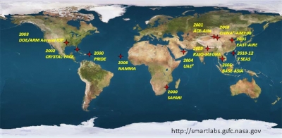
During the past decade we have participated over a dozen international field campaigns. Figure 2 depicts our footprints associated with satellite retrieval/validation projects.
Refereed Journal Publications
Ji, Q., S.-C. Tsay, R. A. Hansell, R. Gautam , S. Bell , J. Huang, Z. Li, and H. Chen, 2011: A Novel Non-Intrusive Method to Resolve the Thermal-Dome-Effect of Pyranometers, Impact on deriving the direct aerosol radiative effect, J. Geophys. Res., in revision.
Ji, Q., and S.-C. Tsay, 2010: A Novel Non-Intrusive Method to Resolve the Thermal-Dome-Effect of Pyranometers, Instrumentation and Observational Basis, J. Geophys. Res., 115, D00K21, doi:10.1029/2009JD013483.
Hansell, R. A., S.-C. Tsay, Q. Ji, N. C. Hsu, M. J. Jeong, S. H. Wang, J. S. Reid, K. N. Liou, and S. C. Ou, 2010: An Assessment of the Surface Longwave Direct Radiative Effect of Airborne Saharan Dust during the NAMMA Field Campaign, J. Atmos. Sci. NAMMA special issue, 67, 1048-1065, doi:10.1175/2009JAS3257.1.
Li, C., S.-C. Tsay, J. S. Fu, R. R. Dickerson, Q. Ji, S. W. Bell, Y. Gao, W. Zhang, J. Huang, Z. Li, and H. Chen, 2010: Anthropogenic Air Pollution Observed near Dust Source Regions in Northwestern China during Springtime 2008, J. Geophys. Res., 115, D00K22, doi:10.1029/2009JD013659.
He, W., H. Chen, Y. Xuan, J. Li, J. Yin, J. Xia, Q. Ji, S.-C. Tsay, 2010, Field Measurements of the Surface Microwave Emissivity for Different Surface Types, Progress in Geophysics, (in Chinese), 25(6), 1983-1993, doi:10.3969/j.issn.1004-2903.2010.06.013.


