")
Task 206
Vegetation 3D Structural Parameters from Multi-Sensor Data
Principal Investigator(s):
G. Sun
Sponsor(s):
K. J. Ranson
Last Updated:
October 26, 2012 15:25:45
Description of Problem
In the year 2010, we have worked on the following issues: : 1) collection of validation data in field; 2) investigation of effects of sampling rates on the accuracy of biomass estimation from lidar data and developing biomass estimation model; 3) polarimetric SAR data processing and application in biomass estimation.
Scientific Objectives and Approach
In next year, we will 1) improve our InSAR radiative transfer model and conduct studies related to the biomass estimation using both polarimetric backscattering and the coherence from InSAR data; 2) use the lidar waveform model to assess the impact of biomass error from lidar and SAR data on overall accuracy and uncertainty of the final biomass mapping product.
Accomplishments
1. Collection of validation data in field:
The test site is located in Maine, USA, in a transition region between boreal and broadleaf biomes. The ~20×100 km study area includes the Northern Experimental Forest (NEF) near Howland, ME (45.25°N, 68.75°W), and the Penobscot Experimental Forest (PEF) near Bradley, ME (44.8°N, 68.6°W). A field campaign funded by the NASA’s DESDynI Development Team was completed in 2009. Twenty four plots (each of 50×200 m, and then divided into sixteen subplots with each of 25×25 m) in NEF and PEF were sampled.
From August 9 to 22, 2010, field measurements were conducted at Howland, Maine by a team from the University of Maryland (graduate student Ms. Wenli Huang, faculty research assistants Jeremy Rubio, Mr. Zhiyu Zhang, Dr. Wenjian Ni and myself), East Carolina University (Dr. Yong Wang ) and Goddard Space Flight Center (Mr. Paul Montesano) with the support from people at the University of Maine. The sampling plots of 50m by 100m, divided into four 50m by 50m subplots were used. The DBH (Diameter at breast height) of all live/dead trees with a DBH ≥10 cm and heights of the three highest trees in each subplot were recorded. Trees with a DBH < 10 cm were counted within a 2m wide transect in the center of the plot tallying the stems by subplots and size classes. In addition two or three LVIS footprints within each of the subplots were located using DGPS and trees within a 20m footprint were recorded. Within the 150mx200m stem map near the main flux tower in Howland test site, 18 LVIS footprints were measured. Total stem biomass was calculated for sampling plots and sampled LVIS footprints using allometric equations.
2. Effects of sampling rates on the accuracy of biomass estimation from lidar data:
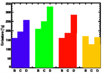
We have explored the forest biomass prediction from various lidar waveform height metrics at different plot sizes ranging from waveform footprint scale (20m) to 1-ha (Huang and Sun, 2010). The model developed using field measurements at waveform footprints was applied to all LVIS waveforms within plots of 25m x 25m, 50m x 50m, 50m x 100m and 50m x 200m, and the biomass averaged from these footprints were compared with biomass measured in these plots. The results show that the prediction accuracy of the model at footprint scale was acceptable (RMSE 30.12 Mg/ha, R² of 0.72 when rh50 was used for biomass prediction). The comparisons between the field biomass and the biomass averaged from LVIS footprints showed that when the plot size increased from 25m by 25m to 50m by 100m and 50m by 200m, the correlations (R²) increased and the RMSE decreased as shown in the following Tables. The accuracy of the locations of field sampling plots were important to ensure the good results. In both of the cases shown in Table 1, a high quality DGPS instrument was used to locale the corners of the sampling plots and the center of the LVIS footprints.
3. Polarimetric SAR data processing and application in biomass estimation:
Biomass from UAVSAR data
Above ground forest biomass and the spatial distribution of vegetation elements have profound effects on the productivity and biodiversity of the terrestrial ecosystems. We evaluated biomass estimation from UAVSAR, NASA’s Uninhabitated Aerial Vehicle Synthetic Aperture Radar (Zhang et al., 2010). The relationships between backscattering coefficients and local incidence angles were examined for different mid-latitudinal forest types. A method based on scattering mechanism and empirical relationships between backscattering and local incidence angles was developed for correcting radiometric distortion caused by large range of the incidence angle. The biomass retrieval model using multi-channel UAVSAR data was then developed. The results showed that RMSE was 40 Mg/ha with a R2 of 0.74. A generalized model for all forest types overestimated quantities in low biomass stands (<100 Mg ha-1) and underestimated quantities in high biomass stands (>200 Mg ha-1). However, these errors were reduced when deciduous, evergreen, and mixed forests were modeled separately. The draft of the paper is under revision after an internal review.
Future Work
1. Model Simulations
A) The biomass or other parameters derived from lidar waveforms will be used as truth in many studies. The lidar waveform is not a direct measurement of the biomass. The error of biomass estimation from lidar waveform will propagate to entire biomass estimation procedure so understanding the sources of the error and having an assessment of its impact on overall accuracy and uncertainty of the final biomass product are critical. We will use the lidar waveform model to investigate the issue.
B) Both sensors are sampling tools and the signatures from these sensors represent the parts of canopy within the resolution cells. In order to match lidar and radar signature, we need to determine what the resolution of radar and the sampling rate of the lidar should be. For example, for a forest stand with a size of one-ha (100m by 100m), we may have 16 radar image pixels in 25m resolution, and probably only 4 lidar footprints of 25m along the track in reality. Model simulations can be used to assess the impact of these factors on the accuracies of biomass mapping algorithms.
C) We will improve our InSAR radiative transfer model and conduct studies related to the project.
2. SAR data processing and Fusion Studies
A) When the UAVSAR inteferometric data is available we will investigate its capability for forest canopy height and biomass estimation in our study site
B) We will investigate the fusion technology using the 2009 LVIS and UAVSAR (and PALSAR) data.
Refereed Journal Publications
Sun, G., K. Jon Ranson, Z. Guo, Z. Zhang, P. Montesano and D. Kimes, Forest Biomass Mapping From Lidar And Radar Synergies, Remote Sensing of Environment, (accepted).
Pang, Y., M. Lefsky, G. Sun, K. J. Ranson, Assessment of the impact of footprint diameter and off-nadir pointing on the accuracy of canopy height estimates from spaceborne lidar, Remote Sensing of Environment, (in press).
Ni, W. J., Guo, Z. F., and Sun, G. Q., 2010, Improvement of a 3D radar backscattering model using matrix-doubling method, SCIENCE CHINA-EARTH SCIENCES, 53 (7): 1029-1035, DOI: 10.1007/s11430-010-0055-6.
Liu, D., G. Sun, Z. Guo, K. J. Ranson and Y. Du, 2010, Three-Dimensional coherence radar backscatter mo
del and simulations of scattering phase center of forest canopies, IEEE Transactions on Geoscience and Remote Sensing, Vol. 48, No. 1, pp 349-357.
Other Publications and Conferences
Ranson, K. J., G. Sun, Effects Of Forest Disturbances On Forest Structural Parameters Retrieval From Lidar Waveform Data, Proceedings of the 2010 IEEE International Geoscience and Remote Sensing Symposium, Honolulu, USA, July 25, 2010, ISBN 978-1-4244-9564-1.
Sun, G., W. Ni, K. J. Ranson, Simulation Studies On Data Fusion Algorithms For Forest Structure From Lidar And Sar Data, Proceedings of the 2010 IEEE International Geoscience and Remote Sensing Symposium, Honolulu, USA, July 25, 2010, ISBN 978-1-4244-9564-1.
Zhang, Z., G. Sun, L. Zhang, Z. Guo, W. Huang, Biomass Retrieval Based On Uavsar Polarimetric Data, Proceedings of the 2010 IEEE International Geoscience and Remote Sensing Symposium, Honolulu, USA, July 25, 2010, ISBN 978-1-4244-9564-1.
Huang, W. L., and G. Sun, 2010, Forest Biomass Estimation Using Lidar-Derived canopy Height Metrics at Maine in USA, AGU Fall Meeting, 13-17 December, 2010, San Francisco, CA, USA.
Task Figures
| Fig. 1 – Comparisons of field biomass with averaged biomass from LVIS footprints for various plot sizes. |


