")
Task 226
Development of the Land Information System (LIS) Framework
Principal Investigator(s):
K. Harrison
Sponsor(s):
C. Peters-Lidard
Last Updated:
October 26, 2012 15:25:53
Description of Problem
NASA’s Land Information System (LIS) is a high performance land surface modeling and data assimilation system. LIS supports global water cycle research, as land surface models predict key variables of the water cycle, including terrestrial water, energy, and biogeophysical states. This task involves adding functionality to LIS through the addition of advanced algorithms to maximize the utilization of available data and science. Recent extensions to LIS include a new optimization and uncertainty analysis subsystem (LIS-OPT/UE). The optimization and uncertainty modeling algorithms in LIS allow for use of satellite (and other) data for parameter estimation and probabilistic prediction. These new capabilities will improve land surface prediction and therefore global water cycle prediction.
Scientific Objectives and Approach
Our specific objectives are:
Support of the Precipitation Measurement Mission (PMM) Land Surface Characterization Working Group (LSWG) by using physically-based models to estimate the dynamics of microwave land emissivity
Further develop the LIS-OPT/UE framework to allow for the calibration and estimation of uncertainty for land surface-coupled models
Implement and test the optimization and uncertainty algorithms
Accomplishments
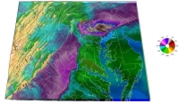
The LIS-OPT/UE system was further extended to allow for the identification of major sources of uncertainty in land surface models and coupled models (emissivity models, landslide models, streamflow, etc.) and the estimation of coupled model parameters. In Figure 1, the benefit of the subsystem for data assimilation is shown. In the example, parameter estimation is shown to be an effective means of bias mitigation, on par with the conventional data assimilation approach, that of a priori scaling.
Refereed Journal Publications
Kumar, S., R. H. Reichle, K. W. Harrison, C. D. Peters-Lidard, S. Yatheendradas, and J. A. Santanello (2012), A comparison of methods for a priori bias correction in soil moisture data assimilation, Water Resour. Res., doi:10.1029/2010WR010261, in press.


