")
Task 243
Development of a holistic statistical framework for precipitation estimation
Principal Investigator(s):
C. Kidd
Sponsor(s):
A. Hou
Last Updated:
October 26, 2012 15:26:09
Description of Problem
The objective is to develop and test techniques for the amalgamation of multi-sensor (satellite and surface) observations to improve global precipitation estimates.
Scientific Objectives and Approach
The project will exploit the wealth of satellite and surface data sets to provide a holistic statistical framework of precipitation estimation. Surface data sets will be sourced from gauge and radar products, and combined with satellite estimates sourced from multi-platforms observations. Results will be inter-compared with current state-of-the-art techniques to assess improvements and application potential. The project involves collaboration with colleagues at ESSIC, at Goddard Space Flight Center and major international partners.
Accomplishments
The initial phase of this project has been to investigate the individual precipitation products that will eventually go into the multi-sensor precipitation product. Since it is envisaged that this will involve multi-satellite, surface radar and gauge observations it is deemed important to characterize the individual components to ensure that their combination is expedited in appropriate and efficient manner.
Therefore, two main objectives during the past year were realized:
– inter-comparison of existing satellite and surface data sets to assess relative performance of currently available data products, and;
– establishing and understanding characteristics and relationships in component data sets.
A test region was selected over northwest European as an initial test region which encompasses a number of countries including the United Kingdom, France, Germany and the Netherlands. The region was chosen due to the large scale coverage by an integrated surface radar network, together with dense gauge observations and temporal and spatial scales appropriate to this study. A study period from 2005 through to 2011 was selected to permit six years of data to be processed. Gauge data from hourly gauges was collected via the British Atmospheric Data Centre and from the GPCC. Radar data was obtained from the UK Meteorological Office, while satellite products (PERSIANN, CMORPH, 3B42RT, CPC merged microwave and NRL-blended) were obtained from their respective providers. In addition, precipitation generated by the operational ECMWF forecast model was obtained via Peter Bauer at the ECMWF. All the data sets were processed to permit comparison of the data sets at a 3-hourly, 0.25 degree resolution, resulting in about 17000 observations for each grid point.
Results from this analysis are summarized below:
– satellite precipitation underestimate precipitation over this region;
– correlations of satellite vs. surface precipitation are generally poor during the cold season, but improve during the warm season;
– conversely, correlations of model vs. surface precipitation are greater during the cold season than the warm season, particularly over continental Europe.
– overall, the operation forecast model precipitation proved to be more consistent than the satellite observed precipitation.
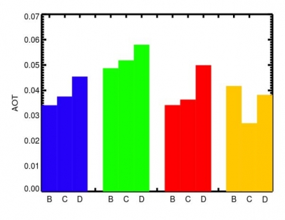
However, further analysis of the data showed that the performance of the ECMWF operational forecast model varied diurnally (see figure below). While satellite products, although having an overall lower level of performance, had little discernible variation across the diurnal cycle, the ECMWF model product showed a significant variation in the false-alarm ratio and the probability of detection.
A time series analysis of the performance of the different products provided some interesting insights into the different data products. It was clear that at monthly timescales the relative performance of individual gauge:radar pixels was consistent, indicating that the errors between different precipitation products (at least for surface data sets) could be defined and mapped. These errors are most likely to result from the retrieval ability of the radar system (e.g. elevation angle/range effect) and local topographical effects influencing the gauge observations. At finer time scales the consistency between the different data locations became more disparate, indicating that the temporal/spatial consistency of the precipitation fields breaks down and errors become increasingly related to the characteristics of the weather system, rather than the retrieved products.
Associated Accomplishments:
In addition to the above tasks, the PI has undertaken a work associated with a number of ground validation campaigns, notably the GPM Light Precipitation Experiment (LPVEx) and the GPM Cold-season Precipitation Experiment (GCPEx). Both these campaigns focused on mid- to high-latitude, light, mixed-phased precipitation regimes that will prove a challenging environment for retrievals from the upcoming Global Precipitation Measurement (GPM) mission. These field campaigns collected extremely useful information on cloud and precipitation that will help our understanding of the processes operating in these regions, and will help improve the satellite precipitation retrievals over these areas.
Future Work
The next stage in this project is to derive relative error maps of individual precipitation products (satellite and surface) to enable a scheme to usefully combined the different estimates. For surface radar, this error map will largely be dominated by range and anaprop errors which in the first instance can be defined through comparison between ‘simple’ satellite techniques (e.g. cloud thresholds vs radar); these can be further refined through iterative calculations to optimize the error boundaries. Within the satellite products, a first-guess error product will be generated through the comparison of the different products, highlighting discrepancies between the different data products. Additional regional data sets from different parts of the globe will be sourced to test the technique and evaluate its’ performance in these regions. In particular, data sets from the US, Australia and Japan will be obtained and processed.
Refereed Journal Publications
Kidd, C. and Levizzani, V. 2011: Status of satellite precipitation retrievals. Hydrological Earth System Science Discussions 7, 8157-8177. doi:10.5194/hessd-8-8157-2010
Kidd, C. and Huffman, G. 2011: Global Precipitation Measurement. Meteorological Applications 18, 334-353. doi: 10.1002/met.284
Tapiador, F.J., Turk, J., Petersen, W., Hou, A.Y., Garc´ıa-Ortega, E., Machado, L.A.T., Angelis, C.F., Salio, P., Kidd, C., Huffman, G.J. de Castro, M. 2011: Global Precipitation Measurement: Methods, Datasets and Applications. Atmospheric Research 104-105, 70-97. doi:10.1016/j.atmosres.2011.10.021.
Kidd, C., Bauer, P., Turk, J., Huffman, G.J., Joyce, R. Hsu, K-L. and Braithwaite, D. 2012: Inter-comparison of high-resolution precipitation products over northwest Europe. Journal of Hydrometeorology. 13, 67-83. doi: 10.1175/JHM-D-11-042
Other Publications and Conferences
Kidd, C. and Hou, A. 2011. Advancing the next generation of global precipitation measurements. European Geophysical Union General Assembly, Vienna, Vienna Centre, Austria
. 3-8 April 2011
Kidd, C. and Hou, A. 2011: Global Precipitation Measurements European Geophysical Union General Assembly, Vienna, Vienna Centre, Austria. 3-8 April 2011
Huffman, G.J., Bolvin, D.T., Braithwaite, D., Hsu, K-L., Joyce, R., Kidd, C., Sorooshian, S., Xie, P. and Yoo, S-H. 2011: The day-1 GPM combined precipitation algorithm IMERG. American Geophysical Union, San Francisco. 5-9 December 2011.
Huffman, G.J., Bolvin, D.T., Braithwaite, D., Hsu, K-L., Joyce, R., Kidd, C., Sorooshian, S., Xie, P. and Yoo, S-H. 2012: Design and early tests of the day-1 GPM combined precipitation algorithm: IMERG. Annual meeting of the American Meteorological Society, New Orleans, 22-26 January 2012.
Web Highlights:
IPWG European Product Comparisons
http://meso-a.gsfc.nasa.gov/ipwg/ipwgeu_home.html
GPM Cold-season Precipitation Experiment blogs:
http://pmm.nasa.gov/mission-updates/gcpex-blog/snow-must-be-saturday
http://pmm.nasa.gov/mission-updates/gcpex-blog/snow-ground-satellites-overhead
http://pmm.nasa.gov/mission-updates/gcpex-blog/more-snow-photos
http://pmm.nasa.gov/mission-updates/gcpex-blog/lake-effect-parking


