")
Task 250
Integration of FEWS-NET into the Land Information System
Principal Investigator(s):
B. Wind
Sponsor(s):
C. Peters-Lidard
Last Updated:
October 26, 2012 15:26:15
Description of Problem
A USGS famine early warning system (FEWS-NET) drought model, Water Requirement Satisfaction Index (WRSI), stood to benefit from being integrated into NASA (Code 614.3) ‘s Land Information System (LIS), which is a software framework for high performance land surface modeling and data assimilation. LIS brings to bear a host of flexible modeling and computing capabilities for those models privileged enough to be integrated into the LIS framework. However, LIS is a general-purpose Fortran (LINUX/UNIX) batch-queue submission shell executable. Whereas, USGS’s most up-to-the-minute implementation of WRSI was a custom Visual Basic .Net (Windows) graphical user interactive (GUI) application. A phased conversion and integration process was required.
Scientific Objectives and Approach
Implementation and integration of WRSI into LIS was to constitute a system called FLDAS-WRSI. The approach to creating FLDAS-WRSI was as follows. Phase 1 required first the identification and conversion of core physics from the 20,000-line USGS visual basic code into a standalone fortran executable, and concomitant testing to ensure against lossy or inaccurate translation. In Phase 2 the fortran physics is being integrated with the Land Information System.
Accomplishments
Phase 1 of the Task was completed from the ground up. All salient WRSI model code features of the 20,000 line Visual Basic .Net code were re-written as half as many lines of fortran90. Testing was designed and conducted to ensure that original and converted codes produced the same output. This work was first performed locally on an x86 32bit host, where for this project all of the development tools had also to be installed from scratch. These installations were Visual Studio 10 in the Windows environment for the Visual Basic work; and gfortran, vi, and svn on Redhat5 through VMWarePlayer for the Fortran conversion.
A sophisticated Start of Season (WRSI parameter) calculation of several additional thousand lines of code was required in addition to the core WRSI algorithm. An SOS algorithm was translated from the Visual Basic equivalent.
For Phase 2, development moved to NASA Center for Climate Simulation’s 14,400-processor Dell PowerEdge C6100 cluster “discover” running the ifort compiler. ESRI’s binary-interleaved (.bil) format was the data file format used by the USGS WRSI model. The first step to enable running of the full WRSI model, beyond the single point calculation, on discover was to create a brand new file I/O library. This several thousand line Fortran (LINUX) library was functionality extracted and translated from a 40,000 line custom Windows library written in Visual Basic. File reading and writing, including grid interpolation for aligning in a consistent fashion data and model run domain resolutions, of the new “bil” library was tested extensively for the many relevant uses, data sources and types, and domain setup scenarios present in the WRSI model.
The WRSI standalone fortran point calculation created during Phase 1 was integrated into LIS. Massive reorganization of the standalone code into LIS structures and several libraries was done. Page 125 of 138
Handling of the model’s precipitation and potential evapotranspiration atmospheric forcing data was integrated into LIS as a new specialized supplemental forcing module. Testing validated.
Features of the USGS WRSI model were ported and expanded further going from the point calculation to that of a full spatial grid. The USGS WRSI model implementation was a highly interactive graphical analysis tool concerned with narrowly-defined local crop growing conditions, whereas LIS was a generic batch calculator of evolving hydrology over an arbitrary spatial domain. The USGS WRSI model was only capable of running one growing season of one crop in one administrative growing region. To run in LIS, the new model needed to be able to run multiple growing seasons, and for multiple crops in multiple administrative growing regions, simultaneously. These new features, and a few of those ported over such as controlled substitution of climatological data for current data and the use of idiosyncratic dekad time steps, required brand new subsystems within and outside of LIS to support FLDAS-WRSI including a parameter management subsystem and multiple time handling tables. The SOS algorithm, meanwhile, was evolved to work seamlessly within LIS as an independent mode of running the same WRSI model. SOS is a parameter to WRSI. Therefore the official LIS post-processor “LVT” was augmented to enable reorganizing by season and reformatting into bil the output of the SOS mode runs for use in the WRSI run mode.
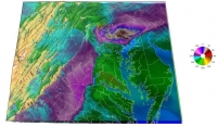
FLDAS-WRSI operation was validated extensively using the 2003-2004 maize season in Malawi by comparing FLDAS-WRSI SOS and WRSI output against the equivalent USGS model outputs. Results were shown to match identically both in memory on discover and on firn.umd.edu, a Dell x86_64 LINUX machine managed at ESSIC and installed with a slightly newer version of ifort, as well as through the use of extensive GrADS visualization techniques. Results, including the figure that follows, were presented at PECORA in November 2011.
Thorough documentation and training of co-workers on building, setup, and running the FLDAS-WRSI model was completed.
Integration of WRSI proceeds to make the FLDAS-WRSI implementation more in the mold of other land surface models in LIS. WRSI will thereby have accessible to it all of the advanced features of LIS available to other fully – integrated models. Meanwhile requirements are being gathered for publication worthy studies and potential operational assimilation of the NASA LIS system, and specifically FLDAS-WRSI, into Earth Resources Observation and Science (EROS) –like prominence within the broader FEWS NET Mission.
Task Figures
| Fig. 1 – |


