Airborne Lidar Measurements Of Atmospheric CO2 Column Concentrations To Cloud Tops
Cazzy Medley
Highlights
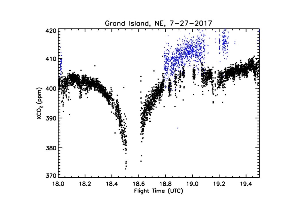
Resolving vertical and horizontal gradients of CO2 for carbon sources and sinks: time series of XCO2 retrievals from lidar measurements made surrounding the spiral at Grand Island, NE on July 27, 2017, over growing corn and soybeans crops with a significant surface drawdown. The black dots are the retrievals from the lidar measurements to the ground and the blue dots are those made to the tops of altocumulus clouds.
NASA Goddard Space Flight Center has developed an integrated-path, differential absorption lidar approach to measure column-averaged atmospheric CO2 (XCO2) towards future spaceborne carbon missions and has conducted several airborne campaigns as demonstrations during the past decade. Jianping Mao is first author on a new paper in Atmospheric Measurement Techniques titled, “Airborne lidar measurements of atmospheric CO2 column concentrations to cloud tops made during the 2017 ASCENDS/ABoVE campaign”.
This study demonstrates the lidar’s capability to fill in CO2 mixing ratio (XCO2) measurement gaps in cloudy regions and to help resolve the vertical and horizontal distributions of atmospheric CO2. The researchers measured the column-averaged XCO2 to a variety of cloud tops with an airborne pulsed multi-wavelength integrated path differential absorption (IPDA) lidar during NASA’s 2017 ASCENDS/ABoVE airborne campaign. Measurements of height-resolved atmospheric backscatter profiles allow this lidar to retrieve XCO2 to cloud tops, as well as to the ground, with accurate knowledge of the photon path length. They validated these measurements with those from an onboard in situ CO2 sensor during spiral-down maneuvers. These lidar measurements were 2–3 times better than those from previous airborne campaigns due to using a wavelength step-locked laser transmitter and a high-efficiency detector for this campaign. This active remote sensing technique can provide all-sky data coverage and high-quality XCO2 measurements for future airborne science campaigns and space missions.
The paper was recently distinguished as a highlight paper by Atmospheric Measurement Techniques with the following public statement from the executive editor:
This paper demonstrates that lidar CO2 measurements can substantially complement current passive remote sensors by providing measurements above clouds and within cloud gaps. Furthermore, lidar provides data at high latitudes where spectroscopy suffers from low solar illumination and challenging albedo variations. This is of particular importance in the context of Arctic amplification. The paper paves the way for future CO2 and also CH4 lidar measurements from satellites.”
Dr. Jianping Mao graduated from the University of Maryland at College Park. He is a mission-oriented research scientist for NASA’s Earth Science Enterprise. Over the past two decades, he has been dedicating to developing remote sensing techniques to observe changes of atmospheric CO2 and CH4, the two most important anthropogenic greenhouse gases that have long been understood to exert a critical influence on Earth’s climate. He has won several NASA awards, including the 2017 NASA Robert H. Goddard Award.

")


