")
ESSIC associate research scientist Augusto Getirana is the lead author of a study published in the journal Remote Sensing of Environment, titled “Deriving three dimensional reservoir bathymetry from multi-satellite datasets”
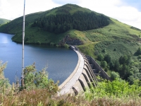
Getirana and his co-authors propose and evaluate different techniques to analyze and access reservoir volume by combining multi-satellite imagery to generate 3-D reservoir bathymetry. They found best estimates are obtained when radar altimetry, digital elevation models (DEM) and land cover datasets are combined.
The proposed algorithms can also be adapted to the future Surface Water and Ocean Topography (SWOT) satellite missions and applied globally. If combined with hydrological models, it could contribute to our understanding of human impact on the water cycle, including water storage and supply resources.
To read the piece in full, click the following: “Deriving three dimensional reservoir bathymetry from multi-satellite datasets”.


