ESSIC/CISESS scientists Yong-Keun Lee and Christopher Grassotti are authors on a new paper in Geophysical Research Letters describing the first attempt to perform a detailed analysis of the stratospheric impact of the eruption from satellite microwave observations. The other authors on the paper are Neil Hindley from University of Bath and Quanhua (Mark) Liu from NOAA’s Center for Satellite Applications and Research.
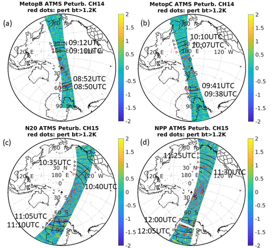
The strongest volcanic eruption since the 19th century occurred on January 15, 2022 at Hunga Tonga-Hunga Ha’apai. It generated unprecedented atmospheric waves not seen before in the satellite era. The researchers used satellite microwave observations from (1) Advanced Technology Microwave Sounder (ATMS) on board the National Oceanic and Atmospheric Administration (NOAA)-20 and the Suomi-National Polar-orbiting Partnership (SNPP) and (2) Advanced Microwave Sounding Unit (AMSU)-A on board Meteorological operational satellite (MetOp)-B/MetOp-C to study these waves in the stratosphere immediately after the eruption. The NOAA Microwave Integrated Retrieval System (MiRS) was applied to these microwave observations to produce atmospheric temperature profiles. The atmospheric Lamb wave and fast-traveling gravity waves are clearly revealed in both the brightness temperatures and the MiRS retrieved temperatures, revealing their vertical phase structures.
Lee is an Associate Research Scientist in the Earth System Science Interdisciplinary Center of the University of Maryland, College Park. He received a B.S. and a M.S. in Atmospheric Science from Seoul National University, and received a Ph.D. in Atmospheric Science from Texas A&M University. He is working on the NOAA Microwave Integrated Retrieval System (MiRS) which is the official operational satellite microwave retrieval algorithm currently being run on data from more than 7 different polar and non-polar orbiting satellites. His interests include remote sensing and data assimilation.
Grassotti is a Senior Faculty Specialist at ESSIC/CISESS. He received a B.S. degree in earth and space science from the State University of New York at Stony Brook, Stony Brook, NY, USA, in 1982, tan M.S. degree in meteorology from the University of Wisconsin-Madison, Madison, WI, USA, in 1986, and an M.S. degree in viticulture and enology from AgroMontpellier, Montpellier, France, in 2007. From 1986 to 1991 and again from 1993 to 2005, he was a Research Associate, Senior Research Associate and Staff Scientist with Atmospheric and Environmental Research, Inc., Lexington, MA, USA. From 1991 to 1993, he was with the Atmospheric Environmental Service, Environment Canada, Dorval, QC, Canada. Since 2008, he has been with the National Oceanic and Atmospheric Administration, NOAA Center for Satellite Applications and Research, National Environmental Satellite, Data, and Information Service, College Park, MD, USA.
To access the paper, click here: “The Hunga Tonga-Hunga Ha’apai Volcanic Eruption as Seen in Satellite Microwave Observations and MiRS Temperature Retrievals”.

")


