Home » ron vogel

Tag: ron vogel

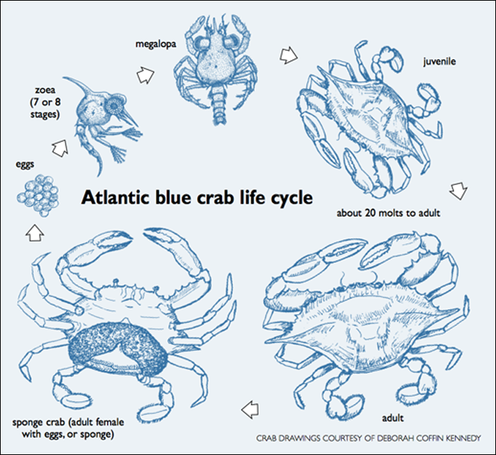
Figure: Blue crabs spend their early larval stages in off-shore water, making them vulnerable to ocean circulation and other highly variable environmental phenomena. (Graphic from Maryland Sea Grant Chesapeake Quarterly, 2012.)

ESSIC at Blue Crab Data Workshop

The Chesapeake Bay Stock Assessment Committee held a Blue Crab Data Workshop from Dec 5-7 to review sources of environmental and biological data that may help model the blue crab population for improving the management of this important marine resource and iconic Chesapeake Bay delicacy. Ron Vogel, ESSIC/CISESS senior faculty specialist, participated in the workshop as a subject matter expert on environmental data sources from satellites to be used in the modeling research.

Read More »
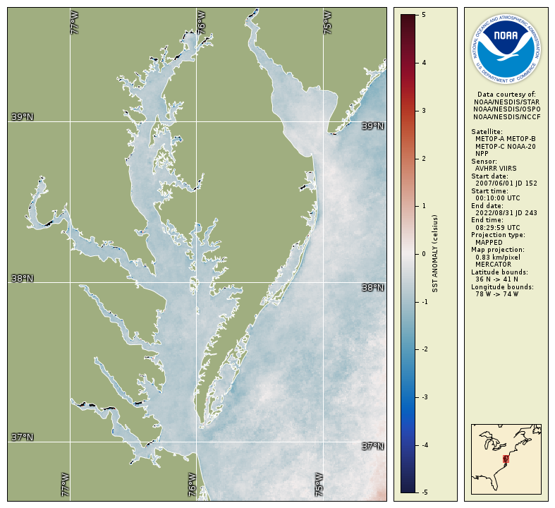
Summer 2023 water temperature anomaly map for Chesapeake Bay shows a 1 degree C decrease in temperature compared to a 2007-2022 baseline, indicating favorable conditions for several key fish species, according to the seasonal fishery impacts report released by the NOAA Chesapeake Bay Office and containing data generated by UMD/ESSIC/CISESS.

Chesapeake Bay has ‘favorable’ summer, finds ESSIC-supported NOAA report

The Virginian-Pilot featured a news article on November 5 highlighting a NOAA report containing an operational satellite data product from ESSIC/CISESS Senior Faculty Specialist Ron Vogel. The report, Synthesis of Environmental Impacts on Key Fishery Resources in the Chesapeake Bay, is released seasonally by the NOAA Chesapeake Bay Office and is used by regional fishery managers to help guide management decisions.

Read More »
A screenshot of the course details in Canvas

Abecassis and Vogel Win NESDIS Collaboration Awards

ESSIC/CISESS Scientists Melanie Abecassis and Ronal Vogel received the NESDIS Collaboration Awards for their contributions as part of a team who created new and upgraded existing content exploiting multimedia, and pivoted the CoastWatch Satellite Course to a virtual environment, hosting educational content on CANVAS at UMD/CISESS.

Read More »
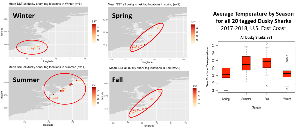
Caption: A class group project presentation slide: Seasonal shifts in U.S. east coast dusky sharks in response to water temperature, 2017-2018, based on tagged shark data from Smithsonian/SERC and satellite sea surface temperature (SST) from NOAA/STAR Coral Reef Watch. Class group project by Roxann Cormier (Univ Mass) and Matthew Larsen (Univ Central FL) for NOAA CoastWatch satellite training Fish-Telemetry Class.

Vogel and Abecassis Teach Class for Fisheries Research Community

Ron Vogel, ESSIC/CISESS Senior Faculty Specialist, and Melanie Abecassis, ESSIC/CISESS Assistant Research Scientist, designed and taught a specially tailored NOAA CoastWatch satellite training class for the fisheries research community. The fishery researchers use tagged fish to understand population dynamics and ecosystem change; however, use of satellite data in this research is still somewhat limited. In order to fill this gap, the class featured satellite parameters that are underutilized in this research but have been identified by the fisheries community as an area for research growth, such as satellite-derived seascapes, geostrophic currents, sea surface height anomaly and salinity.
Read More »
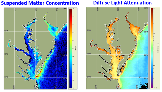
Suspended matter concentration and light attenuation are two satellite water quality products that could be used in combination with other types of data for monitoring water quality improvements and in assessments to determine attainment of water quality standards in Chesapeake Bay. EPA is leading the Chesapeake Bay Program partnership to restore the health of Chesapeake Bay.

Ron Vogel Advises Chesapeake Bay Program

Ron Vogel, ESSIC/CISESS Senior Faculty Specialist, served as a subject matter expert at a scientific advisory panel of the Chesapeake Bay Program (CBP), the EPA-led partnership to restore a healthy Chesapeake Bay. The panel sought to advance the CBP’s current water quality data monitoring program to include new technologies such as satellites to improve its water quality assessments. Vogel outlined the current state of the science of satellite data products available for water quality analysis, including surface water light attenuation and suspended matter concentration.

Read More »
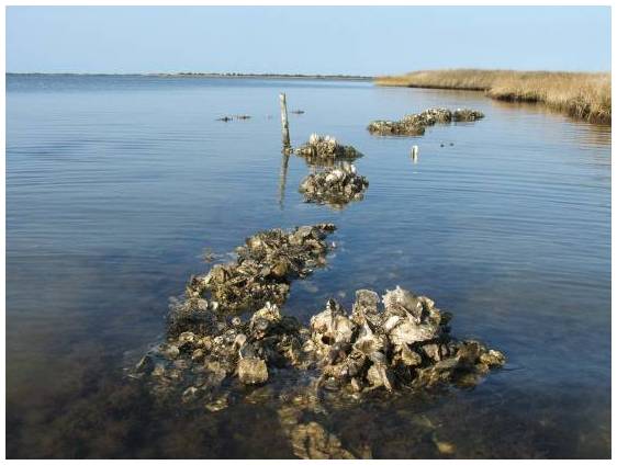
Artificial oyster reefs parallel to the shoreline is a natural way to slow the rate of erosion by catching the wave energy. Credit: USFWS

Innovative Use of Satellite Data Establishes Water Clarity Improvement at Restored Oyster Reefs

Ron Vogel, ESSIC senior faculty specialist, recently co-authored a NOAA Technical Memorandum with colleagues from NOAA’s National Marine Fisheries Service, titled “Using Satellite-Derived Total Suspended Matter Data to Evaluate the Impacts of Tributary-Scale Oyster Restoration on Water Clarity.” In the study, the team sought to explore whether large-scale oyster restoration in the Chesapeake Bay, on the order of 100s of acres, can produce improvements in water clarity that are measurable, and whether satellites can be a tool to help measure that change.

Read More »
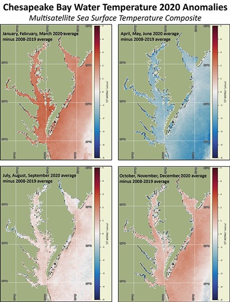
Figure: Satellite SST seasonal anomalies show warmer than average water temperatures from January through March 2020, cooler than average from April through June, near average July through September, and slightly warmer than average October through December.

Chesapeake Bay Office Commends Ron Vogel

ESSIC/CISESS Senior Faculty Specialist Ron Vogel, Operations Manager for the East Coast Node, was recently recognized and highly praised for his contributions to the NOAA Chesapeake Bay Office to identify satellite derived products that support habitat and fisheries management applications.

Read More »
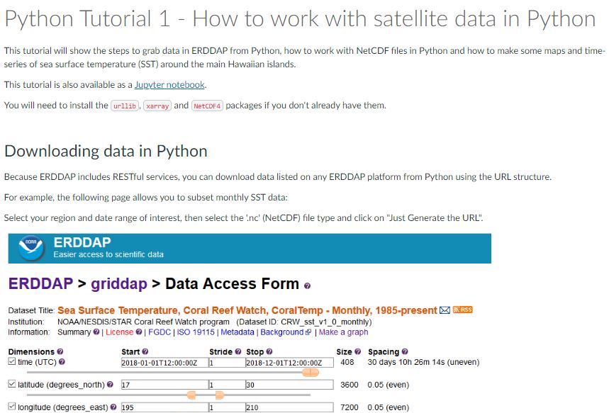
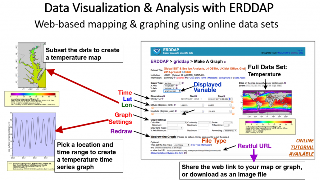
A graphic abstract of Data Visualization and Analysis with ERDDAP

Vogel Presents on Using Oceanographic Satellite Data in K-12

Ron Vogel, ESSIC / CISESS Senior Faculty Specialist, gave a lecture at the Maryland Association of Environmental and Outdoor Education Annual Conference, a conference for K-12 environmental science teachers to explore using oceanographic satellite data in K-12 classrooms. This area has traditionally seen satellite data as too complex for teaching about the environment.

Read More »