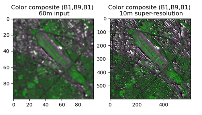
Home » Highlights » Page 15

Category: Highlights

The The Global Precipitation Measurement Mission (GPM) satellite in Earth's orbit

Insights From Coincidences of GPM and CloudSat Satellites

ESSIC/CISESS scientists Yalei You and Sarah Ringerud have a new paper out in IEEE Transactions on Geoscience and Remote Sensing along with University of Minnesota scientists Sajad Vahedizade and Ardeshir Ebtehaj and F. Joseph Turk from Jet Propulsion Laboratory. The paper is titled “Passive Microwave Signatures and Retrieval of High-Latitude Snowfall Over Open Oceans and Sea Ice: Insights From Coincidences of GPM and CloudSat Satellites”. You leads a CISESS task on developing and assessing the NOAA Alaska Regional Snowfall Rate Product.

Read More »
Figure 1. (a) Horizontal distribution of MiRS NOAA-20 ATMS TPW for all of 2019, (b) meridional distribution of statistics for MiRS NOAA-20 ATMS TPW versus ECMWF (black) and GDAS (red) (dots are bias (mm) and lines are standard deviation (mm)): number of pixels are more than 1.2 million for each latitude between 80°S and 80°N. Beyond this area the number of pixels decreases significantly. Global distribution of bias (mm) of (c) MiRS NOAA-20 ATMS TPW – ECMWF TPW, (d) MiRS NOAA-20 ATMS TPW – GDAS TPW, standard deviation (mm) of MiRS NOAA-20 ATMS TPW versus (e) ECMWF TPW and (f) GDAS TPW. All results are for combined ascending and descending orbits in 2019. The red box (120°W ∼ 150°W & 8°N ∼ 12°N) in each plot indicates an area typically characterized by strong convection (CONV area) and the black box (100°W ∼ 120°W & 5°S ∼ 12°S) indicates an area typically dominated by subsidence (SUBS area).

In-Depth Evaluation of MiRS Total Precipitable Water From NOAA-20 ATMS

The MiRS Science Team, composed of ESSIC/CISESS scientists Yong-Keun Lee and Christopher Grassotti, as well as NOAA STAR scientist Mark Liu, published a paper this week titled “In‐Depth Evaluation of MiRS Total Precipitable Water From NOAA‐20 ATMS Using Multiple Reference Data Sets” in Earth and Space Science. Lee was the first author of the study.

Read More »
A visualization of the longest lightning flash

Watch the Longest Lightning Flash Ever

The ESSIC/CISESS Geostationary Lightning Team team, which includes Scott Rudlosky and Daile Zhang, have released a new ArcGIS Story Map via the NOAA GeoPlatform titled “Longest Lightning Flash Ever?”. This website provides stunning visualizations of a recently documented world record flash that covered a horizontal distance of 768 km (477.2 miles) on April 29, 2020. This is equivalent to the distance between New York City and Columbus, Ohio. This flash was recently certified as the longest single flash world record, as covered in an ESSIC press release.

Read More »
Page 1 of the SOLAS report; an image of a porthole looking towards an ocean is the background, with "US SOLAS Science Plan" appearing in front of it.

Gassó and Zamora Co-Author SOLAS Science Plan

Santiago Gassó is one of the co-authors in the recently released science plan by the US Surface Ocean – Lower Atmosphere Study (SOLAS), a global and multidisciplinary research project established to provide international science coordination and capacity building. SOLAS is focused on understanding the key biogeochemical-physical interactions and feedbacks between the ocean and atmosphere that are critical elements of climate and global biogeochemical cycles.

Read More »
Isaac Moradi smiles for the camera, wearing a red gridded button-up and a red tie

Congratulations to Isaac Moradi, Newly Elected Member of the University State Senate

ESSIC/CISESS Research Scientist Isaac Moradi has been elected to the University State Senate as one of the Professional-Track Faculty members. The University Senate, composed of faculty, staff, students, and administrators, is one of the largest and most influential governing bodies at the University of Maryland. As a member of the senate, Moradi will help advise the University President on campus policy matters and concerns, including education, budget, personnel, campus-community, long range plans, facilities, and faculty, staff and student affairs.

Read More »
Artificial oyster reefs parallel to the shoreline is a natural way to slow the rate of erosion by catching the wave energy. Credit: USFWS

Innovative Use of Satellite Data Establishes Water Clarity Improvement at Restored Oyster Reefs

Ron Vogel, ESSIC senior faculty specialist, recently co-authored a NOAA Technical Memorandum with colleagues from NOAA’s National Marine Fisheries Service, titled “Using Satellite-Derived Total Suspended Matter Data to Evaluate the Impacts of Tributary-Scale Oyster Restoration on Water Clarity.” In the study, the team sought to explore whether large-scale oyster restoration in the Chesapeake Bay, on the order of 100s of acres, can produce improvements in water clarity that are measurable, and whether satellites can be a tool to help measure that change.

Read More »