Home » Highlights » Page 17

Category: Highlights

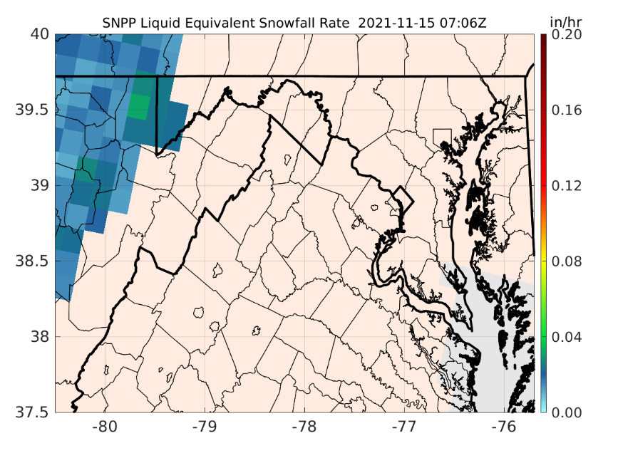
Figure: S-NPP SFR during the first accumulating snow of the 2021-2022 winter season in the central Appalachian counties.

Snowfall Rate Page for Local NWS Office

The ESSIC/CISESS snowfall rate (SFR) team, Huan Meng, Jun Dong, and Yongzhen Fan, set up a webpage for the NWS Sterling, VA Weather Forecast Office (Office Call Sign: LWX) at the request of Luis Rosa, a senior forecaster from the office. The page is set for the LWX county warning area (CWA). Currently, the page has the operational SFR images from five satellites but will be expanded to include the experimental SFR from four other satellites. The SFR product is produced at CISESS from direct broadcast data retrieved from the University of Wisconsin. The product latency ranges from 12-25 min depending on the satellite.


Read More »
Santiago Gasso poses in front of a blurred landscape

Gasso Participates in Remote Sensing International Workshop

On December 1 -3, two members of code 613 participated in an international workshop hosted by the European agency Eumesat and the SOLAS project: “Remote Sensing for Ocean-Atmosphere Interactions Studies and Applications Workshop”. The meeting had an assortment of presentations and discussion panels as well as demonstration of the web and cloud interfaces available for data discovery. Santiago Gassó (ESSIC) participated as one the science organizing committee members, as a panelist and convener.

Read More »
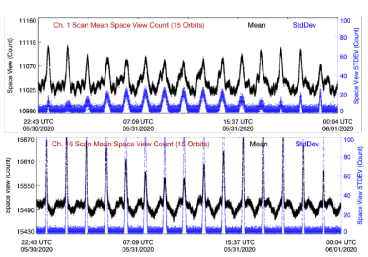
Figure: A lunar intrusion (LI) case occurring on May 31, 2020. Plotted are the original space view counts (black dots) and their standard deviation (blue dots) for NOAA-20 ATMS Channel 1 and 16 during the LI event.

Advanced Technology Microwave Sounder Radiance Data Products Calibration and Evaluation

ESSIC/CISESS Scientist Hu “Tiger” Yang has a new article on the Advanced Technology Microwave Sounder (ATMS) in press at IEEE Transactions on Geoscience and Remote Sensing. The Advanced Technology Microwave Sounder (ATMS) is a passive microwave radiometer for the current generation of polar-orbiting meteorological satellites operated by NOAA. The first two ATMS instruments are onboard the Suomi National Polar-orbiting Partnership (S-NPP) and NOAA-20 satellites. The article explains several critical changes in the ATMS operational calibration algorithm since March 2017. Details of the radiance-based ATMS on-orbit calibration are documented and results of pre-launch calibration error budget analysis and post-launch calibration accuracy evaluation are also presented.

Read More »
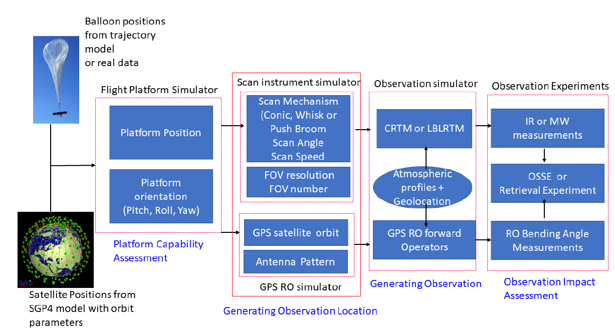
Figure: Flowchart of the satellite and near space platform simulator.

Orbit Simulator for Satellite and Near Space Platforms

ESSIC/CISESS Scientists Likun Wang, Ross Hoffman and Kayo Ide have a new manuscript accepted for publication at the Journal of Atmospheric and Oceanic Technology titled “Orbit Simulator for Satellite and Near Space Platforms Supporting Observing System Simulation Experiments”.

Read More »
Santiago Gasso poses in front of a blurred landscape

Gassó Gives Keynote Talk at Dust Symposium

ESSIC Associate Research Scientist Santiago Gassó was a keynote speaker at the international Blowing South: Southern Hemisphere Dust Symposium held November 8-10, 2021 and organized virtually from Chile. The talk was given during the Present-day: Dynamics session and it was entitled “Southern South America dust activity in relation to long range transport to Antarctica and the Southern Ocean”. No recording was taken of the talk, but slides are available upon request.

Read More »
Dr. Zhanqing Li smiles in a suit in front of a blurry background

Zhanqing Li is a Web of Science Highly Cited Researcher

Web of Science has honored Dr. Zhanqing Li, Professor at ESSIC and University of Maryland’s Department of Atmospheric and Oceanic Science, as a Highly Cited Researcher, an honor bestowed to fewer than 6,200, or about 0.1%, of the world’s researchers, in 21 research fields and across multiple fields.

Read More »
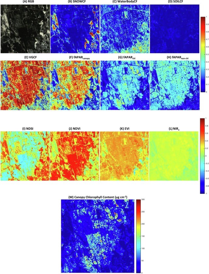
Figure. The 6 × 6 km2 Howland forest area in Maine: (A) the true color image obtained by the EO-1 Hyperion on March 5, 2014 (DOY 64) at a spatial resolution of 30 m; and maps of (B) snow cover fraction (SNOWCF); (C) surface water cover fraction (WaterBodyCF); (D)soil cover fraction (SOILCF); (E) vegetation cover fraction (VGCF); (F) fAPARcanopy; (G) fAPARchl; (H) fAPARnon-chl.

An Evergreen Forest Ecosystem from Satellites

ESSIC/CISESS Scientist Qingyuan Zhang has a new article to be published in International Journal of Applied Earth Observation and Geoinformation that characterizes the seasonally snow-covered Howland boreal forest ecosystem in Maine, USA with satellite images.

Read More »