Home » Precipitation » Page 4

Tag: Precipitation

Figure 1 | Flooding in July 2021 caused mass evacuation in Weihui, Henan province, in China.

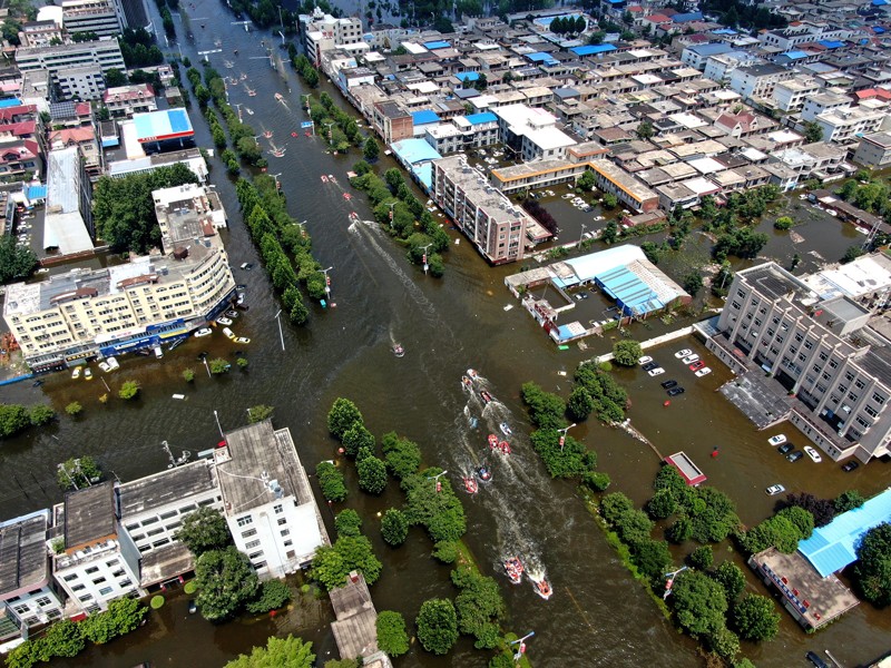
Extreme Rainfall Slows the Global Economy

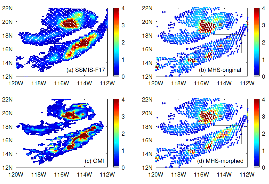
Xin-Zhong Liang was recently published in Nature’s “News and Views” section giving his insight on new research that reported a comprehensive assessment of changes in gross regional product (GRP) relating to excessive precipitation. The study concluded that increases in the numbers of wet days and in extreme daily rainfall dramatically reduces worldwide macroeconomic growth rates.

Read More »
Snow falling around some pine trees

Snowfall Rate Product Captures First Nor’easter in 2022

The first nor’easter of 2022 swept through the Mid-Atlantic and the Northeast on January 2-4, 2022, resulting in a heavy snow accumulation of up to 14 inches in Virginia and southern Maryland and stranding hundreds of drivers on Interstate 95 in Virginia. The NOAA NESDIS Snowfall Rate (SFR) product captured the evolution of the snowstorm with retrievals from the Advanced Technology Microwave Sounder (ATMS) sensor aboard the S-NPP and NOAA-20 satellite missions, and the AMSU-A/MHS sensors aboard NOAA-19, Metop-B, and Metop-C.

Read More »
English: A top view scene of someone doing some research and going through the pages of a book and using a magnifying glass on it. The scene happens on a wooden background. There are also some other research related items in the scene, such as: sticky notes, pencil, ruler or notebook

CISESS Seed Grant Awards Announced

CISESS has announced four Seed Grant Program awards to help develop transformative research that requires a proof of concept to assist NOAA in recognizing and supporting new topics that eventually will be carried out in CISESS.

Read More »
Figure: S-NPP SFR during the first accumulating snow of the 2021-2022 winter season in the central Appalachian counties.

Snowfall Rate Page for Local NWS Office

The ESSIC/CISESS snowfall rate (SFR) team, Huan Meng, Jun Dong, and Yongzhen Fan, set up a webpage for the NWS Sterling, VA Weather Forecast Office (Office Call Sign: LWX) at the request of Luis Rosa, a senior forecaster from the office. The page is set for the LWX county warning area (CWA). Currently, the page has the operational SFR images from five satellites but will be expanded to include the experimental SFR from four other satellites. The SFR product is produced at CISESS from direct broadcast data retrieved from the University of Wisconsin. The product latency ranges from 12-25 min depending on the satellite.

Read More »
Figure 1. MiRS NOAA-20/ATMS retrieved TPW (descending and ascending orbits) on 24 October 2021 over the eastern Pacific and West Coast region. The atmospheric river is clearly seen. Locations of the four vertical cross-sections shown in Figure 2 are indicated by the dashed lines.

NOAA’s MiRs Captures Category 5 Rainfall Event in California

On October 24, a powerful Category 5 (the maximum possible) atmospheric river (AR) occurred over the northern and central parts of California. The storm system featured record breaking precipitation, leading to flooding and mudslides in some locations, along with dangerous winds exceeding 70 miles per hour at higher elevations. San Francisco recorded its fourth highest single-day rainfall amount of over 4 inches. Satellite passive microwave measurements are one of the observational tools that allow depiction of these extreme events, since microwaves are less affected by clouds and precipitation.

Read More »
Figure 1. Global and regional validation of the logistic regression (blue), deep neural network (orange), random forest(green) and XGboost (red) snowfall detection (SD) model for S-NPP.

Fan and Meng Develop New Machine Learning Snowfall Detection Algorithm

ESSIC/CISESS scientists Huan Meng and Yongzhen Fan have recently developed a new machine learning snowfall detection (SD) algorithm, based on eXtreme Gradient Boosting (XGB). The algorithm was developed for the Advanced Technology Microwave Sounder (ATMS) onboard NPP and NOAA-20 as well as the MHS/AMSU-A onboard Metop-A, Metop-B, Metop-C and NOAA-19.

Read More »
A NOAA visualization of Tropical Storm Fred's path up the East Coast, which spreads from Alabama and Mississippi to northern New York and western Massachussets

Performance of NOAA Satellite-based Precipitation Products During Tropical Storm Fred

On August 18, 2021, the western part of North Carolina suffered a catastrophic flash flood caused by Tropical Storm Fred. As part of a NOAA/STAR precipitation validation project, CISESS science team Malar Arulraj, Veljko Petković, Ralph Ferraro, and Huan Meng evaluated the performance of different satellite-based precipitation products during this event using Multi-Radar/Multi-Sensor (MRMS) observations.

Read More »
Figure: This is a precipitation event on 29 August 2020 over the Pacific Ocean near the lower California peninsula. (a) the cross-track radiometer precipitation data, (b) the conical scanning radiometer precipitation data, (c) the reference data for the event, and (d) the “morphed” radiometer precipitation data. The box shows the area of improvement due to morphing.

Improving Satellite Precipitation Retrieval

ESSIC/CISESS Scientists Yalei You, John Xun Yang, and Jun Dong have a new article on using “morphing” to improve rain data from cross-track scanning radiometers. The paper, titled “Improving Cross-track Scanning Radiometers’ Precipitation Retrieval over Ocean by Morphing”, is in press at the Journal of Hydrometeorology.

Read More »
Acid Rain Scenes from Great Smoky Mountains National Park - Clingmans Dome

A Study of Two Impactful Heavy Rainfall Events

Several ESSIC/CISESS scientists including Malarvizhi Arulraj, Jifu Yin, Christopher Grassotti, Veljko Petkovic collaborated on a multi-author, two-part study led by Douglas Miller, Professor of Atmospheric Sciences at the University of North Carolina, Asheville.

Read More »